Dadra and Nagar
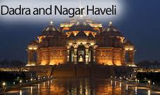
Dadra and Nagar Haveli is a Union Territory in western India. Nagar Haveli is wedged between Maharashtra and Gujarat, whereas Dadra is a enclave 1 km NW surrounded by Gujarat. The shared capital is Silvassa. The larger part spans a large, roughly c-shaped area 12–30 kilometres up-river from the city of Daman on the coast, at the centre of which, and thus outside the territory, is the Madhuban reservoir.
Dadra and Nagar Haveli (DNH) are in the middle of the quite undulating watershed of the Daman Ganga River, which after the reservoir flows through Nagar Haveli and later forms the short southern border of Dadra. The towns of Dadra and Silvassa lie on the north bank of the river. The Western Ghats range rises to the east, and the foothills of the range occupy the eastern portion of the district. While the territory is landlocked, the Arabian Sea lies just to the west in Gujarat.
Geography
The area of Dadra and Nagar Haveli is spread over 491 km2, landlocked between Gujarat to the north and Maharashtra to the south.
The Union Territory comprises two separate geographical units – Dadra and Nagar Haveli. It is close to on the Western coast of India between the parallels of 20º – 0’ and 20º – 25’ of latitude North and between the meridian 72º – 50’ and 73º – 15’ of longitude East. It occupies an area of 491 square kilometres (190 sq mi), comparatively equivalent to the Philippines' Biliran Island. It ranks 4th among the Union Territories and 32nd including the states. The territory is surrounded by Valsad District of Gujarat on the West, North and East and by Thana District of Maharashtra on the South and South-East.
Flora and fauna
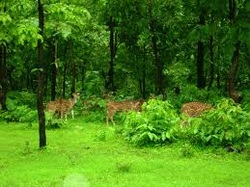
About 43% of the land is under forest cover. However, the reserved forest cohis territory constitutes about 40% of the total geographical area. The protected forests constitute 2.45% of the total land area.
According to satellite data taken in 2008, UT has roughly about 114 square kilometres (28,000 acres) of moderately dense forest and 94 square kilometres (23,000 acres) open forest. As per Forest Survey of India, DNH has two major forest types: tropical moist deciduous forest and tropical dry deciduous forest. The major produce is khairwood/khair and general timber. Teak, sandra, khair, mahara and sisam are the major tree species in the region.
Dnh forest type group mix.png
Tree cover has been estimated around 27 square kilometres (6,700 acres) from the six-year data (2002–08), which is around 5.5% of the total geographical area of DNH.
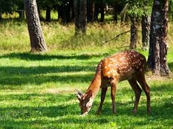
The rich biodiversity makes it a habitat for a variety of birds and animals with numerous trips from inland safari or the coast by tour guides providing eco-tourism. Silvassa's hills and wide, forested buffer land provides a main focal point for wildlife enthusiasts
About 43% of the land is under forest cover. However, the reserved forest cohis territory constitutes about 40% of the total geographical area. The protected forests constitute 2.45% of the total land area.
According to satellite data taken in 2008, UT has roughly about 114 square kilometres (28,000 acres) of moderately dense forest and 94 square kilometres (23,000 acres) open forest. As per Forest Survey of India, DNH has two major forest types: tropical moist deciduous forest and tropical dry deciduous forest. The major produce is khairwood/khair and general timber. Teak, sandra, khair, mahara and sisam are the major tree species in the region.
Dnh forest type group mix.png
Tree cover has been estimated around 27 square kilometres (6,700 acres) from the six-year data (2002–08), which is around 5.5% of the total geographical area of DNH.
The rich biodiversity makes it a habitat for a variety of birds and animals with numerous trips from inland safari or the coast by tour guides providing eco-tourism. Silvassa's hills and wide, forested buffer land provides a main focal point for wildlife enthusiasts
Climate
The climate of Dadra and Nagar Haveli is typical of its type. Being near the coast, all but the sparsely inhabited easternmost parts have a typical north Indian Ocean maritime climate. The summers are hot and become in their later part more humid with temperatures reaching as high as 39° in the month of May. The monsoon starts in the month of June and extends until September. The rainfall is brought by South West monsoon winds. It is known as the Cherrapunji that covers the bulk of western India (apart from the Thar Desert) which produces most of the annual rainfall of 200–250 cm. Winters are between maritime temperate and semi-tropical with temperatures ranging from 14° to 30°, reliably, as with the monsoon, with scant deviation from this range.
The climate of Dadra and Nagar Haveli is typical of its type. Being near the coast, all but the sparsely inhabited easternmost parts have a typical north Indian Ocean maritime climate. The summers are hot and become in their later part more humid with temperatures reaching as high as 39° in the month of May. The monsoon starts in the month of June and extends until September. The rainfall is brought by South West monsoon winds. It is known as the Cherrapunji that covers the bulk of western India (apart from the Thar Desert) which produces most of the annual rainfall of 200–250 cm. Winters are between maritime temperate and semi-tropical with temperatures ranging from 14° to 30°, reliably, as with the monsoon, with scant deviation from this range.
Language
Warli is the language spoken by the Warli people. Agri is spoken by Agri community both are dilects of Marathi-Konkani
A former Portuguese enclave, Silvassa has a significant Roman Catholic population, speaking a distinct dialect of Portuguese. Marathi-Konkani and Gujarati languages are widely spoken. Hindi and Marathi. is also understood
The main tribes are Warlis, Dhodia Kokna, etc.
