Meghalaya
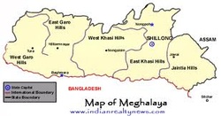
Meghalaya is a state in north-east India. The name means "the abode of clouds" in Sanskrit. As of 2011, the state has a population of 2,964,007 and is the 23rd most populous in the country. Meghalaya covers an area of approximately 300 kilometres in length and about 100 kilometres in breadth. This state is bounded to the south by the People's Republic of Bangladesh and the north by India's Assam. The capital is Shillong, known as the "Scotland of the East", and has a population of 143,007.
About one-third of the state is forested. The Meghalaya subtropical forests ecoregion encompasses the state; its mountain forests are distinct from the lowland tropical forests to the north and south. The forests are notable for their biodiversity of mammals, birds, and plants. It was previously part of Assam, but on 21 January 1972, the districts of Khasi, Garo and Jaintia hills became the new state of Meghalaya.
Meghalaya has predominantly an agrarian economy. The important crops are potatoes, rice, maize, pineapples, bananas, etc. The service sector is made up of real estate and insurance companies. The state has become a hub of illegal mining activity. Meghalaya's gross state domestic product for 2004 was estimated at $1.6 billion in current prices.
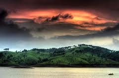
Shillong, the capital of the state, is a popular hill station. There are several falls in and around Shillong. Shillong Peak, also known as the "abode of the gods" is the highest in the state.
Meghalaya is a state in north-east India. The name means "the abode of clouds" in Sanskrit. As of 2011, the state has a population of 2,964,007 and is the 23rd most populous in the country. Meghalaya covers an area of approximately 300 kilometres in length and about 100 kilometres in breadth. This state is bounded to the south by the People's Republic of Bangladesh and the north by India's Assam. The capital is Shillong, known as the "Scotland of the East", and has a population of 143,007.
About one-third of the state is forested. The Meghalaya subtropical forests ecoregion encompasses the state; its mountain forests are distinct from the lowland tropical forests to the north and south. The forests are notable for their biodiversity of mammals, birds, and plants. It was previously part of Assam, but on 21 January 1972, the districts of Khasi, Garo and Jaintia hills became the new state of Meghalaya.
Meghalaya has predominantly an agrarian economy. The important crops are potatoes, rice, maize, pineapples, bananas, etc. The service sector is made up of real estate and insurance companies. The state has become a hub of illegal mining activity. Meghalaya's gross state domestic product for 2004 was estimated at $1.6 billion in current prices.
Shillong, the capital of the state, is a popular hill station. There are several falls in and around Shillong. Shillong Peak, also known as the "abode of the gods" is the highest in the state.
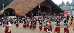
Festivals
Khasis
Dance is at the very heart of Khasi life, rich in repertoire, performed often as a part of the "rites de passage" — the life-cycle of an individual in society or the annual passage of the seasons. Dances are performed at the level of individual villages (Shnong), a group of villages (Raid) and a conglomeration of Raids (Hima). Local or regional flavours and colours bring variations to the basic dance form, which is universal in Khasi folk culture. Types of (Khasi) festivals includes Ka Shad Suk Mynsiem, Ka Pom-Blang Nongkrem, Ka-Shad Shyngwiang-Thangiap, Ka-Shad-Kynjoh Khaskain, Ka Bam Khana Shnong, Umsan Nongkharai, Shad Beh Sier.
Jaintias
Festivals of the Jaintia Hills, like others, contribute significantly to maintaining a balance between man, his culture and his natural environment or eco-system. At the same time it seeks to revive the spirit of cohesiveness and solidarity among the people. Festivals of Jaintias includes Behdienkhlam, Laho Dance, Sowing Ritual Ceremony.
Garos
The main festivals of Garos are Den Bilsia, Wangala, Rongchu gala, Mi Amua, Mangona, Grengdik BaA, Jamang Sia, Ja Megapa, Sa Sat Ra Chaka, Ajeaor Ahaoea, Dore Rata Dance, Chambil Mesara, Do'KruSua, Saram Cha'A, A Se Mania or Tata.
Geography
The state of Meghalaya is also known as the "Meghalaya Plateau". It consists mainly of Archean rock formations. These rock formations contain rich deposits of valuable minerals like coal, limestone, uranium and sillimanite.
Meghalaya has many rivers. Most of these are rainfed and seasonal. The important rivers in the Garo Hills region are Daring, Sanda, Bandra, Bhogai, Dareng, Simsang, Nitai and the Bhupai. In the central and eastern sections of the plateau, the important rivers are Umkhri, Digaru, Umiam, Kynchiang (Jadukata), Mawpa, Umiam or Barapani, Myngot and Myntdu. In the southern Khasi Hills region, these rivers have created deep gorges and several beautiful waterfalls.
The elevation of the plateau ranges between 150 m to 1961 m. The central part of the plateau comprising the Khasi Hills has the highest elevations, followed by the eastern section comprising the Jaintia Hills region. The highest point in Meghalaya is Shillong Peak, which is a prominent IAF station in the Khasi Hills overlooking the city of Shillong. It has an altitude of 1961 m. The Garo Hills region in the western section of the plateau is nearly plain. The highest point in the Garo Hills is Nokrek Peak with an altitude of 1515
Climate
With average annual rainfall as high as 1200 cm in some areas, Meghalaya is the wettest place on earth.The western part of the plateau, comprising the Garo Hills region with lower elevations, experiences high temperatures for most of the year. The Shillong area, with the highest elevations, experiences generally low temperatures. The maximum temperature in this region rarely goes beyond 28 °C (82 °F), whereas sub-zero winter temperatures are common.
The town of Cherrapunji in the Khasi Hills south of capital Shillong holds the world record for most rain in a calendar month, while the village of Mawsynram, near the town of Cherrapunji, holds the record for the most rain in a year.The best time to visit Meghalaya is during the months of March to July.
Flora and fauna
As per the State of Forest Report 2003, published by the Forest Survey of India, Meghalaya has a forest cover of 9,496 km2, which is 42.34% of the total geographical area of the state. The Meghalayan subtropical forests are considered to be among the richest botanical habitats of Asia. These forests receive abundant rainfall and support a vast variety of floral and faunal biodiversity. A small portion of the forest area in Meghalaya is under what is known as “sacred groves” (see Sacred groves of India). These are small pockets of ancient forest that have been preserved by the communities for hundreds of years due to religious and cultural beliefs. These forests are reserved for religious rituals and generally remain protected from any exploitation. These sacred groves harbour many rare plant and animal species. The Nokrek Biosphere Reserve in the West Garo Hills and the Balaphakram National Park in the South Garo Hills are considered to be the most biodiversity-rich sites in Meghalaya. In addition, Meghalaya has three wildlife sanctuaries. These are the Nongkhyllem Wildlife Sanctuary, the Siju Sanctuary and the Bhagmara Sanctuary, which is also the home of the insect eating pitcher plant Nepenthes khasiana.
Due to diverse climatic and topographic conditions, Meghalayan forests support a vast floral diversity, including a large variety of Parasites and Epiphytes, Succulent plants and Shrubs. Two of the most important tree varieties include: Shorea robusta (sal tree) and Tectona grandis (teak). Meghalaya is also the home to a large variety of fruits, vegetables, spices and medicinal plants. Meghalayan is also famous for its large variety of orchids — nearly 325 of them. Of these the largest variety is found in the Mawsmi, Mawmluh and Sohrarim forests in the Khasi hills.
Animal
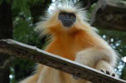
Meghalaya also has a large variety of mammals, birds, reptiles and insects. The important mammal species include elephants, bear, civets, mongooses, weasels, rodents, gaur, wild buffalo, deer, wild boar and a number of primates. Meghalaya also has a large variety of bats. The limestone caves in Meghalaya such as the Siju Cave are home to some of the nation's rarest bat species. There is an interesting population of red pandas in Garo Hills. The state has a remnant population of Wild Water Buffaloes in South Garo and West Khasi Hills districts. The Hoolock gibbon still occurs in all districts of Meghalaya.
Prominent bird species in Meghalaya include the Magpie-Robin, the Red-vented Bulbul, the Hill Myna is usually found in pairs or in flocks in the hill forests of Meghalaya, the Large Pied Hornbill and the Great Indian Hornbill, which is the largest bird in Meghalaya. Other birds include the Peacock Pheasant, the Large Indian Parakeet, the Common Green Pigeon and the Blue Jay. Meghalaya is also home to over 250 species of butterflies, nearly a quarter of all butterfly species found in India.
Common reptiles in Meghalaya are lizards, crocodiles and tortoises. Meghalaya also has a number of snakes including the python, Copperhead, Green Tree Racer, Indian Cobra, King Cobra, Coral Snake and Vipers.
As per the State of Forest Report 2003, published by the Forest Survey of India, Meghalaya has a forest cover of 9,496 km2, which is 42.34% of the total geographical area of the state. The Meghalayan subtropical forests are considered to be among the richest botanical habitats of Asia. These forests receive abundant rainfall and support a vast variety of floral and faunal biodiversity. A small portion of the forest area in Meghalaya is under what is known as “sacred groves” (see Sacred groves of India). These are small pockets of ancient forest that have been preserved by the communities for hundreds of years due to religious and cultural beliefs. These forests are reserved for religious rituals and generally remain protected from any exploitation. These sacred groves harbour many rare plant and animal species. The Nokrek Biosphere Reserve in the West Garo Hills and the Balaphakram National Park in the South Garo Hills are considered to be the most biodiversity-rich sites in Meghalaya. In addition, Meghalaya has three wildlife sanctuaries. These are the Nongkhyllem Wildlife Sanctuary, the Siju Sanctuary and the Bhagmara Sanctuary, which is also the home of the insect eating pitcher plant Nepenthes khasiana.
Due to diverse climatic and topographic conditions, Meghalayan forests support a vast floral diversity, including a large variety of Parasites and Epiphytes, Succulent plants and Shrubs. Two of the most important tree varieties include: Shorea robusta (sal tree) and Tectona grandis (teak). Meghalaya is also the home to a large variety of fruits, vegetables, spices and medicinal plants. Meghalayan is also famous for its large variety of orchids — nearly 325 of them. Of these the largest variety is found in the Mawsmi, Mawmluh and Sohrarim forests in the Khasi hills.
Animal
Meghalaya also has a large variety of mammals, birds, reptiles and insects. The important mammal species include elephants, bear, civets, mongooses, weasels, rodents, gaur, wild buffalo, deer, wild boar and a number of primates. Meghalaya also has a large variety of bats. The limestone caves in Meghalaya such as the Siju Cave are home to some of the nation's rarest bat species. There is an interesting population of red pandas in Garo Hills. The state has a remnant population of Wild Water Buffaloes in South Garo and West Khasi Hills districts. The Hoolock gibbon still occurs in all districts of Meghalaya.
Prominent bird species in Meghalaya include the Magpie-Robin, the Red-vented Bulbul, the Hill Myna is usually found in pairs or in flocks in the hill forests of Meghalaya, the Large Pied Hornbill and the Great Indian Hornbill, which is the largest bird in Meghalaya. Other birds include the Peacock Pheasant, the Large Indian Parakeet, the Common Green Pigeon and the Blue Jay. Meghalaya is also home to over 250 species of butterflies, nearly a quarter of all butterfly species found in India.
Common reptiles in Meghalaya are lizards, crocodiles and tortoises. Meghalaya also has a number of snakes including the python, Copperhead, Green Tree Racer, Indian Cobra, King Cobra, Coral Snake and Vipers.
Tourism
Earlier, foreign tourists required special permits to enter the areas that now constitute the state of Meghalaya. However, the restrictions were removed in 1955. Meghalaya is considered to be one of the most picturesque states in the country. It has enough tourism content to attract tourists of many different interests.
Tourism content
Meghalaya has some of the thickest surviving forests in the country and therefore constitutes one of the most important ecotourism circuits in India. The Meghalayan subtropical forests support a vast variety of flora and fauna. Meghalaya has 2 National Parks and 3 Wildlife Sanctuaries.
Shillong Golf Course, one of the oldest golf courses of India.
Meghalaya also offers many adventure tourism opportunities in the form of mountaineering, rock climbing, trekking and hiking, water sports etc. The state offers several trekking routes, some of which also afford an opportunity to encounter rare animals such as slow loris, assorted deer and bear. The Umiam Lake has a water sports complex with facilities such as rowboats, paddleboats, sailing boats, cruise-boats, water-scooters and speedboats.
Meghalaya has an estimated 500 natural limestone and sandstone caves spread over the entire state including most of the longest and deepest caves in the sub-continent. Krem Liat Prah is the longest cave, and Synrang Pamiang is the deepest cave. Both are located in the Jaintia Hills. Cavers from United Kingdom, Germany, Austria, Ireland and the United States have been visiting Meghalaya for over a decade exploring these caves. Not many of these have however been developed or promoted adequately for major tourist destinations.
Important tourist spots
Cherrapunji is one of the most popular tourist locations in north-east of India. The town is well known and has guided tours of Tree Root Bridges. It lies to the south of the capital Shillong. A rather scenic 50 kilometre long road connects Cherrapunji with Shillong.
The popular waterfalls in the state are the Elephant Falls, Shadthum Falls, Weinia falls, Bishop Falls, Nohkalikai Falls, Langshiang Falls and Sweet Falls. The hot springs at Jakrem near Mawsynram are believed to have curative and medicinal properties.
Meghalaya is also known for its "sacred groves". These have been preserved by the traditional religious sanction since the ancient days. The Mawphlang sacred forest, also known as "Law Lyngdoh," is one of the most famous sacred forests. It's located about 25 kilometres from Shillong. It's a must visit for nature lovers.
Nongkhnum Island located in the West Khasi Hills district is the biggest river island in Meghalaya and the second biggest in Asia. Its 14 kilometres from Nongstoin. The island is formed by the bifurcation of Kynshi River into the Phanliang River and the Namliang River. Adjacent to the sandy beach the Phanliang River forms a very beautiful lake. The river then moves along and before reaching a deep gorge, forms a pretty waterfall about 60 meters high called Shadthum Fall.
The Mawlynnong village located near the India-Bangladesh border is known for its cleanliness. The travel magazine Discover India declared the village as the cleanest in Asia in 2003, and the cleanest in India in 2005. Some of the interesting features include the presence of a Living Root Bridges and another natural phenomenon of a boulder balancing on another rock. The emergence of the village as a new tourist spot has been one of the most remarkable developments in the last decade. Video Link
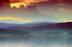
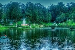
Meghalaya also has many natural and manmade lakes. The Umiam Lake (popularly known as Bara Pani meaning Big water) on the Guwahati-Shillong road is a major tourism attraction for tourist. Meghalaya has several parks; Thangkharang Park, the Eco-park, the Botanical Garden and Lady Hydari Park to name a few. Dawki, which is located at about 96 Kilometres from Shillong is the gateway to Bangladesh and affords a scenic view of some of the tallest mountain ranges in Meghalaya and the Bangladesh border lands.
Balpakram National Park with its pristine habitat and scenery is a major attraction The Nokrek National Park, also in Garo Hills has its own charm with lot of wildlife.
Earlier, foreign tourists required special permits to enter the areas that now constitute the state of Meghalaya. However, the restrictions were removed in 1955. Meghalaya is considered to be one of the most picturesque states in the country. It has enough tourism content to attract tourists of many different interests.
Tourism content
Meghalaya has some of the thickest surviving forests in the country and therefore constitutes one of the most important ecotourism circuits in India. The Meghalayan subtropical forests support a vast variety of flora and fauna. Meghalaya has 2 National Parks and 3 Wildlife Sanctuaries.
Shillong Golf Course, one of the oldest golf courses of India.
Meghalaya also offers many adventure tourism opportunities in the form of mountaineering, rock climbing, trekking and hiking, water sports etc. The state offers several trekking routes, some of which also afford an opportunity to encounter rare animals such as slow loris, assorted deer and bear. The Umiam Lake has a water sports complex with facilities such as rowboats, paddleboats, sailing boats, cruise-boats, water-scooters and speedboats.
Meghalaya has an estimated 500 natural limestone and sandstone caves spread over the entire state including most of the longest and deepest caves in the sub-continent. Krem Liat Prah is the longest cave, and Synrang Pamiang is the deepest cave. Both are located in the Jaintia Hills. Cavers from United Kingdom, Germany, Austria, Ireland and the United States have been visiting Meghalaya for over a decade exploring these caves. Not many of these have however been developed or promoted adequately for major tourist destinations.
Important tourist spots
Cherrapunji is one of the most popular tourist locations in north-east of India. The town is well known and has guided tours of Tree Root Bridges. It lies to the south of the capital Shillong. A rather scenic 50 kilometre long road connects Cherrapunji with Shillong.
The popular waterfalls in the state are the Elephant Falls, Shadthum Falls, Weinia falls, Bishop Falls, Nohkalikai Falls, Langshiang Falls and Sweet Falls. The hot springs at Jakrem near Mawsynram are believed to have curative and medicinal properties.
Meghalaya is also known for its "sacred groves". These have been preserved by the traditional religious sanction since the ancient days. The Mawphlang sacred forest, also known as "Law Lyngdoh," is one of the most famous sacred forests. It's located about 25 kilometres from Shillong. It's a must visit for nature lovers.
Nongkhnum Island located in the West Khasi Hills district is the biggest river island in Meghalaya and the second biggest in Asia. Its 14 kilometres from Nongstoin. The island is formed by the bifurcation of Kynshi River into the Phanliang River and the Namliang River. Adjacent to the sandy beach the Phanliang River forms a very beautiful lake. The river then moves along and before reaching a deep gorge, forms a pretty waterfall about 60 meters high called Shadthum Fall.
The Mawlynnong village located near the India-Bangladesh border is known for its cleanliness. The travel magazine Discover India declared the village as the cleanest in Asia in 2003, and the cleanest in India in 2005. Some of the interesting features include the presence of a Living Root Bridges and another natural phenomenon of a boulder balancing on another rock. The emergence of the village as a new tourist spot has been one of the most remarkable developments in the last decade. Video Link
Meghalaya also has many natural and manmade lakes. The Umiam Lake (popularly known as Bara Pani meaning Big water) on the Guwahati-Shillong road is a major tourism attraction for tourist. Meghalaya has several parks; Thangkharang Park, the Eco-park, the Botanical Garden and Lady Hydari Park to name a few. Dawki, which is located at about 96 Kilometres from Shillong is the gateway to Bangladesh and affords a scenic view of some of the tallest mountain ranges in Meghalaya and the Bangladesh border lands.
Balpakram National Park with its pristine habitat and scenery is a major attraction The Nokrek National Park, also in Garo Hills has its own charm with lot of wildlife.
